Bernhard Rinner and his team develop algorithms for coordination and route planning for multi-drone systems with applications in area monitoring, search&rescue and disaster support.
Drones have evolved from bulky research platforms to everyday objects that enable a variety of novel applications. One of the current challenges is to unite individual drones into an integrated autonomous system, in which they operate as a networked team to provide novel functionality that multiple individual drones will never be able to achieve. Such multi-drone systems have been the subject of research at the University of Klagenfurt for more than ten years. Several professors and their research groups have developed solutions for wireless networking, path planning, distributed decision making and cooperation, aerial imaging, and, more recently, autonomous navigation. They established the drone hub Klagenfurt – bundling the various drone research activities – and initiated the doctoral school on networked autonomous aerial vehicles.
Activities started in 2008 when the team in Klagenfurt developed a system that provides functionality similar to Google Earth and Microsoft Virtual Earth but capturing small areas with much higher resolution: A user first outlines the area of interest on a map. The drones fly over the specified area, take images, and provide an accurate and up-to-date overview picture of the environment. “Our solution requires mission planning and coordination for multiple aerial vehicles,” explains senior researcher Markus Quaritsch. The system computes the flight routes for the individual drones taking into account the maximum flight time due to battery constraints. A flight route consists of a sequence of waypoints specified in GPS coordinates, the flight altitude, and a set of actions for every waypoint such as taking a photo or setting the orientation. The drones autonomously fly according to the computed plan without any need for human interaction.
In another project we studied the benefit of coordination in search operations. In multi-drone cooperative search, each drone maintains a map of the search area that serves as the drone’s knowledge base about the state of the search region. The drones move around and observe parts of the search region, gaining information using the on-board surveillance sensors (e.g., cameras). The ultimate goal is to determine the necessary actions in order to gain as much information as possible about target locations. The drones must therefore decide what search action to take (i.e., when and where to move in the search region), what information to send or receive, and when to share information to complete the search efficiently.
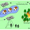
More recently we focussed on coordinating the drones’ routes for persistent surveillance applications. Jürgen Scherer, who completed his dissertation entitled “Multi-Robot Persistent Surveillance with Connectivity Constraints,” exemplifies the basic persistent surveillance problem, “Robots have to visit all given sensing locations periodically while maintaining a multi-hop connection to a base station with the objective to minimize the duration between two consecutive visits of a sensing location.” Due to the connectivity constraint, the robots mutually restrict their possible movements and traditional patrolling strategies cannot be applied directly to the problem because they do not coordinate the robots’ movement in space and time to maintain connectivity.
In a further investigation, we relaxed the connectivity constraint and allowed delay-tolerant data transfers to the base station. Thus, continuous connection from all robots to the base station is not required, and the robots can collaboratively transfer the data in a store-and-foward fashion.
Funded projects
- Doctoral School on Networked Autonomous Aerial Vehicles (NAV)
Deputy speaker. Funding from University of Klagenfurt, 2017-2021 - Self-Organizing Intelligent Network of UAVs (SINUS)
Principal investigator. Funding from EU/KWF/BABEG, 2013-2015 - Erasmus Mundus Doctoral School on Interactive and Cognitive Environments (ICE)
Co-initiator and speaker Klagenfurt University. Funding from EU, 2010-2018 - Collaborative Microdrones (cDrones)
Principal investigator. Funding from EU/KWF/BABEG, 2008-2012
Key Publications
- Jürgen Scherer and Bernhard Rinner. Multi-Robot Persistent Surveillance With Connectivity Constraints. IEEE Access, 8:15093-15109, 2020.
- Evsen Yanmaz, Saeed Yahyanejad, Bernhard Rinner, Hermann Hellwagner and Christian Bettstetter. Drone Networks: Communications, Coordination, and Sensing. Ad Hoc Networks, Elsevier, 68:1-15, 2018.
- Daniel Wischounig-Strucl, Bernhard Rinner. Resource Aware and Incremental Mosaics of Wide Areas from Small-Scale UAVs. Machine Vision and Applications, pages 20, 2015.
- Asif Khan, Evsen Yanmaz and Bernhard Rinner. Information Exchange and Decision Making in Micro Aerial Vehicle Networks for Cooperative Search. IEEE Transactions on Control of Networked Systems, pages 12, 2015.
- Saeed Yahyanejad and Bernhard Rinner. A fast and mobile system for registration of low-altitude visual and thermal aerial images using multiple small-scale UAVs. ISPRS Journal of Photogrammetry and Remote Sensing, pages 14, September 2014.
- Markus Quaritsch, Karin Kruggl, Daniel Wischounig-Strucl, Subhabrata Bhattacharya, Mubarak Shah and Bernhard Rinner. Networked UAVs as Aerial Sensor Network for Disaster Management Applications. e&i Elektrotechnik und Informationstechnik, 127(3) pages 56-63, 2010. Springer.